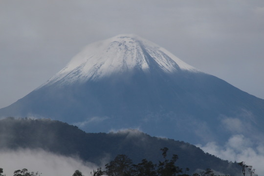
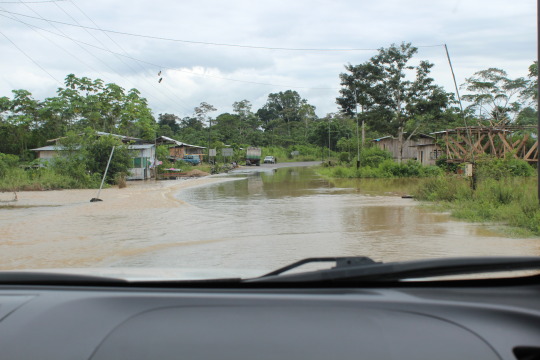
By the time the meeting adjourned with Juan Arco, the director of the Macas Airport, his niece, my friend Adam Gebb and Marcelo who is our Shuar guide, the weather had drastically changed since our arrival after a beautiful 4+ hour drive from Cuenca. Transiting Parque Nacional Sangay on a windy mountain road the park is a UNESCO World Heritage Site (like Cuenca Centro) and is home to Volcan Sangay, a 17,400ft active volcano with a snow capped perfect cone. The weather had been mostly clear with typical mountain clouds and it was the same on arrival in Macas.

Valley to Macas. There’s a road in there somewhere.
Our plan was to depart after the meeting but unfortunately the tiny Cessna, 4 seat plane doesn’t fly well in sideways rain. When flying into the Amazon over the Cutucu and Shaimi ranges and landing on a primitive grass runway cleared by machetes on the edge of the Mangozita River you need the weather to cooperate. Juan Arco explained that during this time of year the weather could remain foul for days and suggested we backtrack and travel many more hours by bus to our planned final destination and do the trip in reverse. Clearly our plan to fly in and land up river and find a canoe to take us downriver is logically the best. We were anxious to start our journey and had suggested we fly the next morning when it is typically clearer before the afternoon storms roll in.
“That sounds nice but you don’t get to decide!” Juan Arco rebutted with a snicker. We all agreed we could look at the weather in the morning and decide and set out to find lodging for the evening. I needed to buy rubber boots for the journey into the deep Amazon anyway and we enjoyed our last night with a comfortable bed and good meal.
Fortunately the mist in the morning lifted and we lugged our gear to the airstrip, got weighed, paid the fare, tax and wandered around the hanger until we were called to board. Aside from the desk attendant, pilot and baggage handler, we were the only other people around. This is my kind of airport.

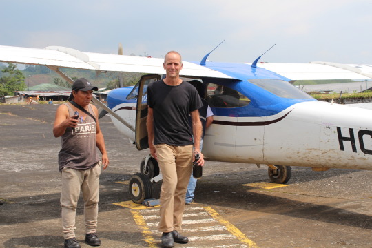
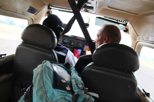
The cockpit of the tiny plane was smaller than most taxis we use around Ecuador. They had the plane loaded specifically to balance the weight. Adam offered me the front seat as I had the better camera but the pilot said we were specifically seated for weight distribution. That explained Adams giant backpack leaning against me in the seat between Marcelo and I in the back. After ambling down the runway we managed enough speed to get off the tarmac and immediately banked east towards the Amazon.
Within minutes of the bustling Macas (pop. 30,000) we were skimming the dense canopy of virgin rainforest. Looking down I was imagining what secrets lie below the treetops. There are few places with undisturbed forest like this and especially so close to developed areas. The next half hour we saw a couple of clearings with primitive dwellings but no roads. All travel was by foot and possibly pack animal. Many parts of the dense forest, growing on the steep mountainous land, looked impassable.
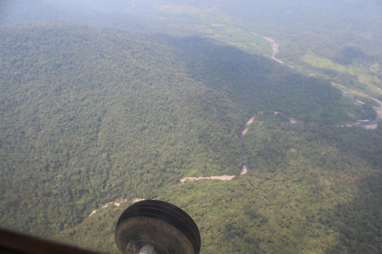
Finally the river appeared and we got a glimpse of our airstrip in the distance before circling around the surrounding bluffs. As we descended the plane slowed we were soon looking into the trees as the canopy whooshed by beyond the wingtips. The bumpy landing was exciting though never particularly scary. It’s just another day for the pilot.
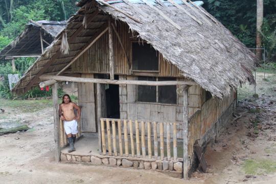
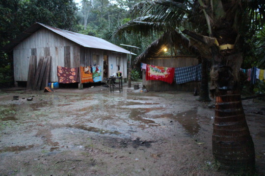
We quickly unloaded the plane while surrounded by a dozen uniformed schoolchildren. The heat and humidity was clearly a noticeable change from Cuenca and even Macas…about what you would expect for the Amazon jungle. We shuttled the gear to the river and took a quick dip while asking about canoe transport to Miazal, our first village.

Our longboat canoe measured 25 feet plus an outboard outfitted with a 6 ft long shaft and a tiny prop for skimming the surface of the river. It wasn’t too stable and fortunately I am accustomed to tippy boats. We asked how far down river was Miazal and the teenage driver flatly responded “3 curves” like that would give us the info we needed. He was keen at navigating the features, currents and obstacles of an ever changing Mangozita River. The rapids were small but still made us grip he gunwale a little tighter as we approached any whitewater.

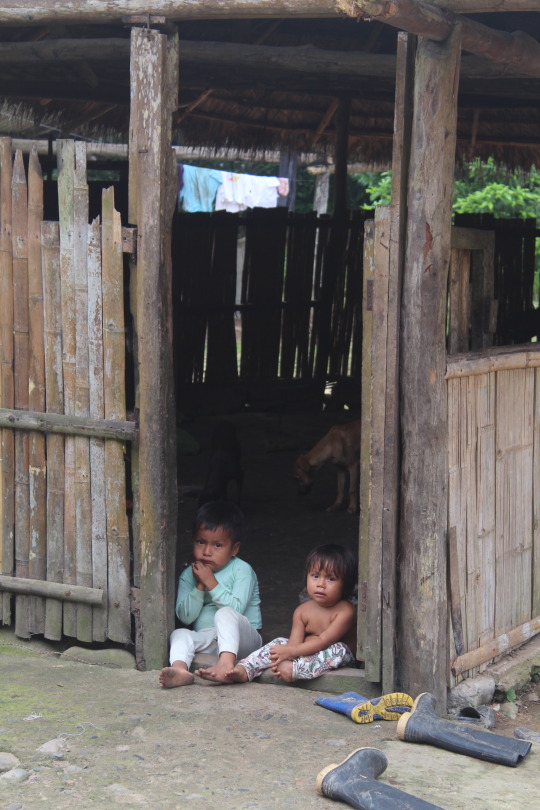
When traveling in the areas of the Shuar territory, which we were transiting, there are no public lands, per se. It is a community of scattered families and their connecting parcels. It is fairly remote and I doubt many of the locals make trips outside the area. There is no cell service (though some locals did have phones) and no internet nor electricity. Yes…off the grid. So the locals don’t really have any outside information or news.
We hired Marcelo to be our guide, mostly a liaison to vouch for our presence on their land. More than once when we desired to pull up to a village, while landing the canoe somewhere below a bluff, we heard shouts and warnings from above…voices from the trees saying we were not welcome…don’t stop…move on. It was hard to hear if they were speaking Shuar or spanish but it was clearly not welcoming. Having the local boat operator and Marcelo with us didn’t matter…they didn’t want Adam and I there.
In Miazal and subsequently everyone we talked to were aware of a new rumor that some gringo men had come to a village upriver and cut off the heads of 3 Shuar girls. Obviously not true and when we heard this the first time we laughed and thought it was a joke and soon realized they were serious. The two different places we camped for a couple of days each didn’t really believe this (so they say) but they did inform us that this rumor was strong and well traveled among the territory. Regardless of what locals really knew or thought about this, it made our trip a little tense and put restrictions on our ability to explore or go anywhere without a local family member in tow.
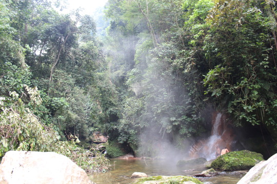
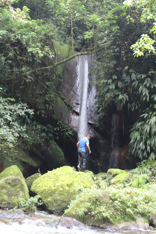
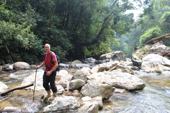
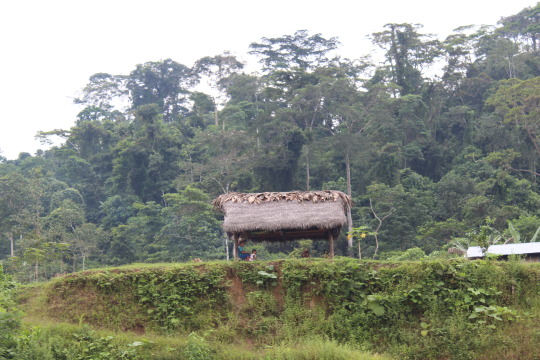
From Miazal we hiked to the next village to get permission to visit the Aguas Termales. Not your regular natural springs this sacred location has a 50ft waterfall with a temp of about 104F cascading into a mountain jungle river with other towering, cool falls. The 2 hour hike was on a very primitive trail and without our local guide, Luis, and his machete we would have never found it. We crossed the river half a dozen times and finally I gave up trying to keep the inside of my rubber boots dry and copied Luis and Marcelo who would just let them fill. We scrambled up steep banks that are frequently flooded and washed out and avoided all the pokey, stinging plants and animals of the jungle. These mountains are home to the 3 big cats that reside in Ecuador, the Puma, Panther and Jaguar. Though we didn’t see any, nor did we expect to, we did see some big paw prints down by the river.

Cold Cascada
After some time soaking, swimming and admiring this special place we sensed some nervousness from Luis as he kept looking at the sky. The weather seemed pleasant but he knew that it could be raining miles away and the flood could hit us before the rain even appeared. It would be impossible to get back with any level of inundation. So we gathered our snacks and clothes and returned a different way along the river.
Back at the village I was passed a giant bowl fashioned from a natural gourd containing chicha, the tradicional drink made from the yucca root. Harvested, cleaned, boiled and mashed. While mashing the women chew handfuls of the mixture and spit it with their saliva back into the mixture. Ferment for a day or so and serve it up! The weak alcoholic flavor is mild with a light, fizzy tingle on the tongue. The bowl is passed around and around or more commonly passed to a woman outside the circle who wipes the rim and offers it to the next man. It is an ancient tradition and I sheepishly accepted the patriarchal ways of this ritual. I felt it was important to participate and later found out they don’t really trust visitors that don’t drink chicha. This was done everywhere we went for our week in the territory.

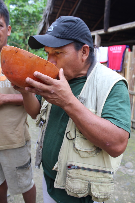

Chicha-tender

A couple of hours down river was our second stop at the community of Los Angeles. Esteban and his family have a big parcel with a variety of fruit trees and a soccer field surrounded by various casitas. In our exploration Esteban pointed out a plant from which they make Ayahuasca. I got an immediate tingle up my spine as I caressed the trippy, twisty vine of the soul…a regular reaction whenever referencing Ayahuasca from my experiences with the medicine in the past decade. He informed me they had a ceremony the previous night and I was both bummed I missed another opportunity as well as somewhat relieved.

Esteban showing me the Ayahuasca Vine
Daughters Cabañas
None of this had any effect on the regular Sunday gathering at this property. Many families arrived with food while music blared from a giant single speaker and various official soccer matches were played, all the while the skies poured down on the party. At dusk, Esteban took us on a canoe ride and long walk exploring his property. The trail was flooded and knee deep for a long section as we approached his daughters’ compound, a tidy area with a couple of cabanas and easy access to the river.
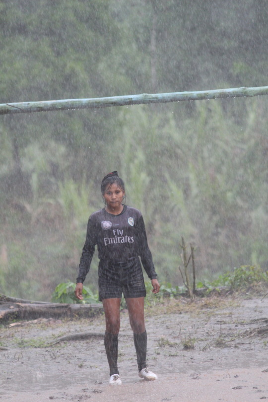
Right behind this goal the riverbank steeply descends. If they are lucky the ball will get hung up in the brush, otherwise it rolls or flies into the swift river below.
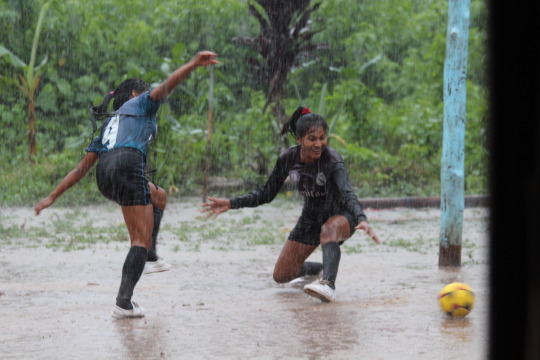
Goooooooooaaaaaaallllllll!!!
Our last night was spent cooking for the entire village as they lined the walls of the casita watching as if we were a 1 act play in the round. Using a camp stove we cooked up a vegetable stir-fry with jalapeño tuna topping with fruit and salami appetizers, finishing with Ritz and Oreos and they could not have been happier. Later we spoke with Esteban about the weather and departing mañana and after some discussion he matter of fact stated the familiar saying “I know you need to catch a ride but you don’t get to decide”. Duly noted.

Waiting for Dinner
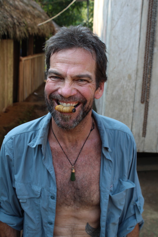
Palm Larva. Yep, I ate it, crunchy black head and all.
Fortunately in the morning the rains had subsided while I made strong coffee for Esteban and his wife and chatted with the kids as they took turns drawing pictures in my journal. Before long we were packed and ready for the couple of hour trip downriver to meet our ride from Cuenca. Though the rain had stopped the river was still cresting and it took all hands on deck to keep an eye for floating trees, snags and changing currents. Half way down river we spotted the lost canoe from the night before, hung up in some overhanging branches which were normally 12 ft above the surface but now provided the perfect “arms” to stop the runaway canoe and cradle her until we arrived.

Our mission to recover the boat was dangerous and charged with the type of excitement I remember from a decade of sailing on Guava Jelly when these types of situations arose. We can do this but be aware, move deliberately, don’t do anything stupid and make matters worse. Crossing the strong current we made a wobbly approach and as Marcelo grabbed the line of the stranded canoe from the bow of our boat the current swung us around and pushed the 2 hulls parallel. While attempting to hold the position and not trying to pinch fingers the 6ft long prop shaft (still running) was stuck between the hulls, craned 180 degrees forward and spinning between Adam and my head. We remained calm and managed to get everything sorted and towed the canoe across the river, tying her up safely for Estebans’ son to gather later.

Riverfront Property
We arrived at what we thought was Puerto Morona to a flooded and confusing ‘dock’. Squeezing in and climbing over other boats we managed to exit without falling in the drink. This town, though small, had the regular port feel. Interesting and grimy with all the action at the intersection of the dock and the only road passing through town. We clearly were outsiders but people were generally curious and friendly while we ordered our almuerzo (lunch) and a beer.

Flooded Dock.
Ready to return to my crazy family in Cuenca, our ride was nowhere to be found and pondering another night in the Amazon..where would we stay, we decided to get a mixto (pick-up truck taxi) and hope we see him on the way. A few minutes down the road when we reach Puerto Morona…wha?!?…he was there. We had been waiting in Puerto Morona(ish). Do you know there are a half a dozen San Rafaels within 30 minutes of the capital of Costa Rica? Also quite a few San Antonios, San Isidros, San Franciscos, San Others in the same area? In my confusion I remembered this and shrugged it off…we had a ride home!
Climbing into a 2016 extended cab, 4 wheel drive Toyota, I felt almost at home with the familiar comforts the Amazon failed to provide. 5 minutes later our driver explained the only reason he arrived at Puerto Morona on time (the correct Puerto, not the one where we were waiting) was his truck. He approached the washed out road…no road remained, just a little sliver of flat ground over the curb of the shoulder, beyond the avalanche mud. The locals said you can’t pass (aka “you don’t get to decide) and our driver reminded them he just came thru an hour before. We were waved passed and we repeated this process a couple of more times. Hours later I was embraced with the hugs from the wee ones I so missed.
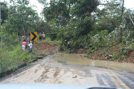
One of many landslides covering the road home.
Aside from the Amazon exploration and adventure, this trip had another more noble purpose. Adam Gebb has been putting together plans to save the rain-forest, albeit only the corridor we visited that is the Shuar Territory.
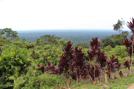
Looking over 2000+ miles of Amazon jungle basin before it reaches the Atlantic Ocean.
Like so many other unspoiled lands and last frontiers of the world, this area has no protection from the exploiting petroleum, mineral and other industries that threaten to destroy it. From those industries there is currently an influx of money and deals negotiated to steal these lands from the indigenous locals and they have little representation to prevent this from moving down that irreversible path.

The black oval is roughly the Shuar Territory. You can see the value of a bio-corridor between the 2 National Parks. Cuenca is to the west in the Andes.
Adam’s multi-level plan is relatively simple though it faces many hurdles and even if things move forward the progress will be at a glacial pace. Change is difficult when dealing with the many facets…the landholders, government departments, conservation organizations and the research, reports and knowledge necessary to achieve protected status.
Traveling to the territory to meet with the locals and persuade them to even listen to ideas about conservation is a daunting task. That was the purpose of this trip and as you may have read, it was difficult to obtain trust.
Briefly the plan, with the approval and support of the Shuar community, would be to establish eco-friendly tourism to the area by means of a simple hut to hut hiking corridor. This would get the locals involved, bring them some income and hopefully with the reports of like minded travelers and tourists who visit the area, alert the larger conservation organizations (where the future money would come from) to the importance of ultimately establishing a protected bio-corrodor connecting the Parque Nacional Cordilla del Condor on the Ecuador/Peru border to the Parque Nacional Sangay in the Andes of Ecuador.
Though it sounds straight-forward and obviously necessary, there are many steps in between and every turn requires much planning and revisions, meeting, studies, funds, travel, etc. All the while maintaining focus and awareness to the delicate needs and desires of the Shuar community. I hope the unforeseen hurdles are few and the project is successful.

Leave a comment